

GPS technology, the basis of today's position-locating products including car navigation systems, is made possible by the 31 GPS satellites that orbit the earth. The GPS unit receives radio signals directly from these satellites to calculate your position and automatically record your journey. And it's so easy thanks to innovative features that let you harness the capabilities of GPS to map your memories.
The GPS unit lets you double the enjoyment of using a camera – still or video – whether you're island-hopping in the Mediterranean or cataloguing local landmarks for a heritage society.
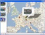
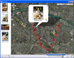
Track your memories
While you move from place to place with the GPS unit turned on, your coordinates are logged in its memory. Once this data is matched with the time stamps of your photos, they can be automatically positioned on a map, so you can trace the route you travelled. The matching is performed by the GPS unit itself, or by the supplied software. Then the route can be managed as a single event, complete with the photos and videos you shot while the GPS unit was logging your position.
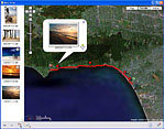
Enjoy video clips on maps
Videos** you've shot using a Handycam® or Cyber-shot can be linked to the GPS log data and displayed on the online map* as clickable thumbnail images. Simply clicking on a thumbnail will start playback of the video clip in a separate pop-up window. Now you can relive your memories on maps, complete with both photos and videos, for a more fulfilling experience.
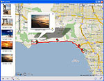
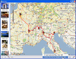
Enjoy automatic slideshows on maps
Just click on the icon to start the slideshow, which displays your photos*** on the online map* in sequential order along the route that you travelled. This adds a sense of movement and chronology to your trip. And since it frees you from having to click to see each new image, you can sit back, relax, and enjoy the ride. If the map is zoomed in too tightly, the display will even automatically scroll around along the route so you won't miss any of the pictures. Depending on the software used, you can even choose a satellite image as the map background.
Share your story by e-mail
Now that your story is complete, it's time to show and tell. The map view that is displayed on your computer screen can easily be sent as an e-mail attachment to your friends and family. So instead of just describing your vacation or business trip, you have a graphical map that illustrates the route with your very own pictures.
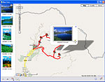
Retrace your trip in 3D using Google Earth™
The Map View function of the supplied PMB (Picture Motion Browser) software can generate the KML files used by Google Earth™. As well as mapping your photos to 2D satellite images of the ground, you can also switch to 3D maps (where available) with all your pictures accurately embedded at the appropriate locations.
Fitting snugly in your palm, the GPS unit is designed for optimum convenience, from the clear data display to the simple way in which it adds location data to the photos on a memory card.
High sensitivity
The GPS unit features a tracking sensitivity of -159dBm. This means you can carry it in your pocket or shoulder bag as you move around. Trees, trains, and tall buildings will not prevent the unit from picking up GPS signals.
LCD screen
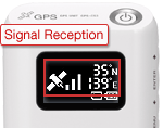
Your position is not just recorded in the memory of the GPS unit; it is also displayed on the LCD screen. This clearly indicates the date and time, and also displays battery level and GPS signal reception.
Easy matching in GPS Unit
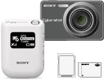
You can now perform matching of photos and GPS data simply by inserting the memory card from your camera into the GPS unit, which features a card slot for a Memory Stick DUO™ or SD card. The display indicates when matching is complete. (Note that video and Raw data must be matched using the GPS Image Tracker software on your computer.)
There's even more enjoyment if you have the SONY BRAVIA (with Photo Map function) for big-screen photo and map viewing with family and friends.
Photo Map
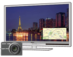
A BRAVIA TV, connected to the Internet, can display a small map in one corner of the screen when you put on a slideshow for your family. Photo Map reads the GPS data from each photo and uses this to automatically select the appropriate map and location.
- Availability of the BRAVIA with Photo Map function depends on the model and region. Screenshot with map is for illustrative purposes only.
- *Maps and satellite images powered by Google Maps™ mapping service. Google and Google Earth™ are trademarks of Google Inc.
- **Movie files taken with Cyber-shot or Handycam® are compatible; the user must install PMB (Picture Motion Browser) supplied with the Cyber-shot or Handycam®.
- ***Still images (JPEG format) taken by any digital camera with Exif 2.1 or later are compatible. Raw images taken by a SONY α DSLR camera are also compatible.